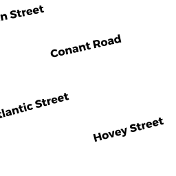
43 CONANT RD
Owner Information
NIEDOLISTEK GREGORY W
43 CONANT RD
QUINCY, MA 02171


Property Details
43 CONANT RD is classified as a Single Family Residential (Bungalow).
The primary structure on this property was built in 1900. There are 2,780ft2 of built area within this property. There is 876ft2 of residential/living space within this property. This property is listed as having 4 rooms.
43 CONANT RD is valued at $359,400. The land is valued at $227,200 and the structures are valued at $127,200. There is an additional valuation of $5,000 on this property.
This property is in Zone RES A. Confirm with local Zoning Board authorities to ensure there are no overlays or other easements on this property.
The most recent deed for 43 CONANT RD is recorded at the local registrar in Book 31952, Page 0585. 43 CONANT RD was last sold on Tuesday, December 10, 2013 for $238,000.
Assessment data from fiscal year 2020.
Flood Data
According to the FEMA National Flood Hazard Layer, this property does not appear to be in a flood zone. It may also be in an area not yet reviewed. Nonetheless, confirm this information prior to taking any action.
To view the flood hazards around this property, create a FEMA "Firmette" Map of the area around 43 CONANT RD.
Broadband Internet Providers
| Provider | Type | Bandwidth (mbps) | |
|---|---|---|---|
| GCI Communication Corp. | Satellite | 0 | 0 |
| VSAT Systems, LLC. | Satellite | 2 | 1 |
| Verizon New England Inc. | DSL | 7 | 0 |
| Comcast | Cable | 1000 | 35 |
| Viasat Inc | Satellite | 100 | 3 |
| HughesNet | Satellite | 25 | 3 |
| Starry, Inc. | Fixed Wireless | 200 | 200 |
Broadband service provider data from December 2020.
Adjacent Properties
- 39 CONANT RD
Single Family Residential owned by MARTINKUS ANNMARIE - 45 CONANT RD
Single Family Residential owned by HANSON WILLIAM C - 300 ATLANTIC ST
Single Family Residential owned by TAM DAVID - 298 ATLANTIC ST
Single Family Residential owned by LIN KUN XING - 294 ATLANTIC ST
Single Family Residential owned by MCADAMS JEROME F ETAL TREES